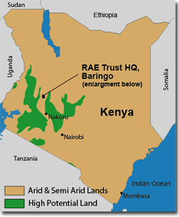
Map of Kenya: Dryland Areas and RAE Trust Headquarters
Over 80% of Kenya is classified as arid or semi-arid,
with less than 20% of the country's landmass
regarded as high potential, suitable for intensive
agriculture and forestry.
Migration from over crowded high potential areas to
more marginal areas has further increased the population
pressure on Kenya's spreading drylands, threatened by diminishing
resources, poor productivity and increasing poverty.
The RAE Trust Headquarters are situated north-west of Kenya's
capital Nairobi, with the largest nearby town of Nakuru
some 100 km away. RAE Headquarters are located on-site in the
semi-arid lowlands of the Baringo District, in the
Kenya's Rift Valley, at:
00°38'04" North Latitude
36°02'18" East Longitude.
Map
of Baringo Lowlands: RAE Focus Areas
RAE has concentrated its work in the degraded Baringo
lowlands. RAE
Headquarters are located on the shores of Lake Baringo,
the only large source of fresh water in the area.
Lake Baringo is a tourist destination, well known for
its wide variety of birds. The Lake is threatened
with extinction due to heavy siltation from severe soil
erosion on the lowlands and deforestation in the
surrounding hills.
RAE's area of focus in the Baringo lowlands extends
amongst the three agro-pastoralist groups of the
area; the Tugen, Pokot and Njemps. All three
groups participate actively in the RAE programme.
Their transference of knowledge to the multiple visitors
they receive has contributed greatly towards the
continued expansion of the RAE programme to other
dryland areas.